Sunday, November 13, 2011
Geomorphological time scales
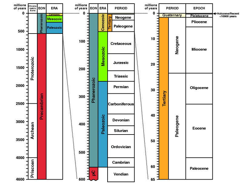
As I mentioned in one of my first lectures, it is important to get to grips with the geological time scale. The version reproduced below is a useful one for geomorphologists.
 Most (but not all) of the land surface we see around us has been predominantly sculpted by geomorphic processes over the last 65 million years - the period filled by the column on the right hand side of the timescale as shown above. Indeed, in many places the Quaternary period (the last 2.4 million years or so or the top sliver of the right hand column) has seen the major landscape evolution.


Monday, November 7, 2011
Tibetan plateau uplift and its impacts on China
The impressive uplift of the Tibetan plateau over the Quaternary period (averaging just over 1mm a year - sounds slow, but for long term uplift this is spectacular!) has had important consequences for the landscape, climate and ecology of China. These impacts are nicely and simply explained in this article by Dianfa Zhang and colleagues in 2000 in Environmental Geology:
http://activetectonics.asu.edu/teaching/GLG494-ICOG/Tibetan%20Plateau.pdf
Check it out as it will help you understand the complex links between tectonic uplift, denudation and climate.
http://activetectonics.asu.edu/teaching/GLG494-ICOG/Tibetan%20Plateau.pdf
Check it out as it will help you understand the complex links between tectonic uplift, denudation and climate.
Canary Islands volcanic activity
Recent subsea volcanic activity has been reported off El Hierro the smallest and newest island in the Canaries off NorthAfrica (see my lecture on tectonics and geomorphology for more details about the Canaries). The latest reports record 'jacuzzi' like disturbances of the sea off El Hierro as hot basaltic lava is being produced, and worries of a potential tsunami also float around the blogosphere. The events remind us of the importance of volcanic activity in shaping oceanic island geomorphology. Check out the latest reports at:
http://www.wired.com/wiredscience/2011/11/renewed-eruptions-at-el-hierro-in-the-canary-islands/#more-85516
http://www.wired.com/wiredscience/2011/11/renewed-eruptions-at-el-hierro-in-the-canary-islands/#more-85516
Thursday, November 3, 2011
Dauphin Island, Alabama...storms, plants and animals shaping the coast
A good example of climatic and ecological influences on geomorphic processes comes from the coastal barrier islands of the Gulf Coast of USA, where I recently attended a conference. Dauphin Island, Alabama, for example, was badly affected by Hurricane Katrina, which cut off the west side of the island completely. The image from Google Earth below shows what the island looks like today. If you scroll to the west you will, eventually, find the western tip of the island which is now separated from the rest by some distance.
View Larger Map
The USGS have carried out extensive surveys of Dauphin Island before and after Hurricane events - check out this website for some really good images and explanations of the impact of Hurricane Katrina:
http://coastal.er.usgs.gov/hurricanes/katrina/lidar/dauphin-island.html
As a result of day to day coastal processes the island is constantly changing, and hurricanes regularly 'reset' the sediment stores. However, organisms also play a big role here - both erosive and protective. The local authorities are currently using plants to aid sedimentation on the backshore dunes - as shown in the image below. They discourage walking over the dunes, as this damages the vegetation and releases sand.

'These dunes aren't made for walking'
Further down the beach, there is widespread evidence of organisms (probably crabs) causing widespread mobilisation of sediment through extensive burrowing activity.

The results of an energetic burrowing crab
The question for geomorphologists is how to quantify in a meaningful way the different contributions of plants and animals to moving and storing sediment here, and to compare them waves and winds (all low magnitude and high frequency processes) and also with the high magnitude-low frequency impacts of storms and hurricanes. How would you do that?
Thanks to Dr Carole Sawyer, University of South Alabama for introducing me to Dauphin Island.
Online geomorphological vignettes
No, I didn't know what a 'vignette' was either, until I came across this website
http://serc.carleton.edu/vignettes/index.html
which has a whole series of short articles on key topics in geomorphology. They have a strong USA flavour (or should that be 'flavor') to them, but many are helpful case studies of tectonic, climatic and other influences on geomorphology. Explore them and see what you think.
I found this one particularly interesting as it deals with the indirect control of climate change on erosion through the climatic influence on vegetation:
Links between climate change, vegetation and erosion in Australia during the last 100,000 years
Tuesday, November 1, 2011
Darwin's earthworm experiments
As I mentioned in my 'Ecology and geomorphology' lecture Charles Darwin really started the ball rolling on investigating the impacts plants and animals make on geomorphic processes. He did this largely through his experimental studies on earthworms and the amount of sediment they move. His work is highly important in providing one of the very first (and still a well-cited) set of figures quantifying how much geomorphic work earthworms do. One of the key tasks awaiting geomorphologists today is to provide further datasets on different species, such as badgers, turtles, ants, gophers, ground squirrels, moles, packrats...I could go on...
Here's an interesting article and radio story about Darwin's earthworm experiments and follow-up work that has been done on them:
http://www.npr.org/templates/story/story.php?storyId=100627614
Here's an interesting article and radio story about Darwin's earthworm experiments and follow-up work that has been done on them:
http://www.npr.org/templates/story/story.php?storyId=100627614
Paraglacial processes shaped the Lake District
..well, partly at least! This paper by Peter Wilson nicely documents five rock slope failures in the Lake District and, based on quite detailed fieldwork (don't get bogged down in the details), suggests that they are of paraglacial origin. My lecture on 'Climate, climate change and geomorphology' introduced the concept of paraglaciation, and this paper should help to bring it to life. When you look at the paper, think about the sources of evidence Wilson uses and what other evidence would be really useful to test whether or not the rock slope failures actually WERE a result of paraglaciation. You can access a pdf of the paper at:
http://www.science.ulster.ac.uk/ae/docs/Peters%20papers/Wasdale.pdf
http://www.science.ulster.ac.uk/ae/docs/Peters%20papers/Wasdale.pdf
Subscribe to:
Posts (Atom)