Welcome to the wonderful world of geomorphology

Sunday, November 27, 2011

Curiosity heads off to Mars

On Saturday 26th November the Mars Science Laboratory mission launched safely from Florida. It should land on Mars in early August next year, ready for the amazingly well-equipped Curiosity rover vehicle to start its exploration of Gale Crater.  The aim of the mission is to search for signs that conditions  might once have been favourable for life, by looking for evidence in the sedimentary rocks found in the crater.  Geomorphology will play an important part of this mission, and geomorphologists will also learn a lot from it.  Already there are many links between planetary science and terrestrial geomorphology. For example, much of our understanding of the surface conditions on Mars comes from looking at what the Americans call 'analog' environments - i.e. places on Earth that are similar to places on Mars, such as Antarctica and hyper-arid deserts such as the Atacama and the Namib deserts.


HiRise image of barchan dunes on Mars

Also, as the above image shows we can now see an amazing range of landforms on Mars which are leading geomorphologists to ask all sorts of questions about how they are formed.


The IAG Planetary Geomorphology Working Group posts monthly images with accompanying  explanations most of which deal with some aspects of comparisons between landforms and processes on Earth and Mars.  Check out the collection at the following address - especially the one from December 2010 on rock breakdown on Earth and Mars which I put together.

http://www.psi.edu/pgwg/images/index.html

Geomorphologists on Earth are highly envious of the equipment that the Mars Science Lab mission has on-board the Curiosity Rover.  Have a look at the NASA factsheet (link below) to find out all the information about the physical and chemical make-up of the rocks that Curiosity will be able to glean in the field.

http://www.jpl.nasa.gov/news/fact_sheets/mars-science-laboratory.pdf

Fingers crossed, if all goes to plan, Curiosity and the Mars Science Lab mission should start sending back some new and intriguing data next summer, which will not only throw further light on its geological, geomorphological and possibly biological history.

Wednesday, November 23, 2011

San Pedro landslide - a slow build up to a dramatic event

San Pedro is on the Palos Verdes peninsula just south of Los Angeles - and in Sunday 20th November 2011 a slow-moving landslide which had been moving at a few 10s of mms per day for several months suddenly failed dramatically in a few minutes. A 200m stretch of the main Paseo del Mar road slid away from the clifftops, dropping some 30m.  It's a beautiful hilly area, with upmarket housing and fantastic coastal views.  It's also a hotspot for landslides, as evidenced by the excellent California Geological Survey landslide map produced in 2007 which you can access at:
ftp://ftp.consrv.ca.gov/pub/dmg/pubs/lsim/LSIM_PalosVerdes.pdf
Be patient as it is a large file and takes some time to download.  if you read the text on the right hand side of the map you'll find out more about why the area is prone to landslides.  The essential reasons are:


  1. The peninsula is underpinned by Miocene rocks, including shale.  Many of the landslides are located on the easily erodible shale.
  2. The peninsula is crossed by the Palos Verdes fault and folded into a complex anticlinal structure.
Human activities have also been blamed for the high occurrence of landslides here. Not only building extensively on the clifftops, but also mis-managing drainage systems and, one factor quoted in the local news as being responsible for the most recent event - cold war underground missile silos are allegedly found in the area.  On Sunday 20th November 2011 it was a horrendously rainy day in Los Angeles - over 20mm of rain fell in a few hours.  

You can explore the coast on Google Maps below - the site of the 20th November 2011 landslide is at the centre of the view - but if you head N and W up the coast you can see vast numbers of houses and impermeable concrete structures along the clifftops.  Surely asking for trouble?


View Larger Map


Think about how would describe the causes of this landslide, using Mike Crozier's predisposing, triggering and maintaining factors framework. Was the rainstorm on November 20th the trigger? Or not?

Sunday, November 13, 2011

Landscapes as palimpsests

Geomorphologists often use the term 'palimpsest' to describe the landscape or terrain we see around us.  What they mean by this is that the landscape has been shaped by many periods of geomorphic change, each change acting upon a surface that has been already altered by previous processes.  In many cases, evidence of the former processes can be seen partially hidden by the most recently produced landforms.  For example, Quaternary glaciations deposited till and other material over much of the lowlands of Britain - which partially obscured landforms produced in the Tertiary period.  In some cases pre-existing topography such as folded landscapes produced by tectonics influences the location of later erosion and sedimentation.


An example of folding of Miocene sediments, producing a syncline over which later Quaternary sediments have been deposited.  From the Mojave Desert, California.  

But where does this term 'palimpsest' come from and what does it mean?  A palimpsest comes for the Greek for 'scraped again' and is used by historians to refer to manuscripts (often written on parchment or vellum) which have been rubbed out and new texts written over the top.  Often this process has been repeated many times.  A good example, which forms the basis of an exhibition at the Walters Art Museum can be found described and illustrated at:


Geomorphological time scales

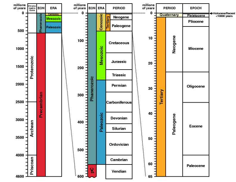
As I mentioned in one of my first lectures, it is important to get to grips with the geological time scale.  The version reproduced below is a useful one for geomorphologists.

Most (but not all) of the land surface we see around us has been predominantly sculpted by geomorphic processes over the last 65 million years - the period filled by the column on the right hand side of the timescale as shown above.  Indeed, in many places the Quaternary period (the last 2.4 million years or so or the top sliver of the right hand column) has seen the major landscape evolution.

Monday, November 7, 2011

Tibetan plateau uplift and its impacts on China

The impressive uplift of the Tibetan plateau over the Quaternary period (averaging just over 1mm a year - sounds slow, but for long term uplift this is spectacular!) has had important consequences for the landscape, climate and ecology of China.  These impacts are nicely and simply explained in this article by Dianfa Zhang and colleagues in 2000 in Environmental Geology:

http://activetectonics.asu.edu/teaching/GLG494-ICOG/Tibetan%20Plateau.pdf

Check it out as it will help you understand the complex links between tectonic uplift, denudation and climate.

Canary Islands volcanic activity

Recent subsea volcanic activity has been reported off El Hierro the smallest and newest island in the Canaries off NorthAfrica (see my lecture on tectonics and geomorphology for more details about the Canaries).  The latest reports record 'jacuzzi' like disturbances of the sea off El Hierro as hot basaltic lava is being produced, and worries of a potential tsunami also float around the blogosphere.  The events remind us of the importance of volcanic activity in shaping oceanic island geomorphology.  Check out the latest reports at:
http://www.wired.com/wiredscience/2011/11/renewed-eruptions-at-el-hierro-in-the-canary-islands/#more-85516

Thursday, November 3, 2011

Dauphin Island, Alabama...storms, plants and animals shaping the coast

A good example of climatic and ecological influences on geomorphic processes comes from the coastal barrier islands of the Gulf Coast of USA, where I recently attended a conference.  Dauphin Island, Alabama, for example, was badly affected by Hurricane Katrina, which cut off the west side of the island completely. The image from Google Earth below shows what the island looks like today. If you scroll to the west you will, eventually, find the western tip of the island which is now separated from the rest by some distance.


View Larger Map

The USGS have carried out extensive surveys of Dauphin Island before and after Hurricane events - check out this website for some really good images and explanations of the impact of Hurricane Katrina:
http://coastal.er.usgs.gov/hurricanes/katrina/lidar/dauphin-island.html

As a result of day to day coastal processes the island is constantly changing, and hurricanes regularly 'reset' the sediment stores.  However, organisms also play a big role here - both erosive and protective. The local authorities are currently using plants to aid sedimentation on the backshore dunes - as shown in the image below. They discourage walking over the dunes, as this damages the vegetation and releases sand.

'These dunes aren't made for walking' 

Further down the beach, there is widespread evidence of organisms (probably crabs) causing widespread mobilisation of sediment through extensive burrowing activity.

The results of an energetic burrowing crab

The question for geomorphologists is how to quantify in a meaningful way the different contributions of plants and animals to moving and storing sediment here, and to compare them waves and winds (all low magnitude and high frequency processes) and also with the high magnitude-low frequency impacts of storms and hurricanes. How would you do that?

Thanks to Dr Carole Sawyer, University of South Alabama for introducing me to Dauphin Island.